Planning, Zoning and Development Review
Best practice: Arlington County’s TOD Vision

A vision for TOD created by Arlington County planners in the 1970s has been credited for setting the stage for the enormous success of TOD there. It is recognized as a national model for creating a TOD vision, then realizing it through implementation of the countywide general land use plan and station area sector plans.
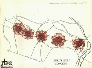
Planning and development around five Washington Metro Orange Line stations along the Rosslyn-Ballston Corridor exemplify the County’s successful TOD efforts. In the early 1970s, prior to the opening of the Orange Line, the County conducted extensive planning policy studies and adopted the policy report – RB’72 – Alternative Land Use Patterns, which provided growth strategies for the corridor.
 RB’72 called for "the concentration of mixed-high density use near Metro stations in bulls eyes of approximately 1/4-mile in radius." Subsequently, the county sharpened the TOD vision through the development and adoption of the 1975 Long Range County Improvement Program, which laid the policy guidelines for more detailed planning of the corridor and its five station areas. Between1977 and 1984, the county adopted the general land use plan for the corridor and a sector plan for each of the five station areas.
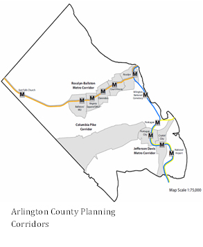
The General Land Use Plan, an element of Arlington County’s Comprehensive Plan, was adopted in 1961 and amended periodically through 2013. The plan specifies three planning corridors along existing or potential transit lines – Rosslyn-Ballston, Jefferson Davis and Columbia Pike. The General Land Use Plan Map outlines the type, intensity, and location of land uses for the three major corridors and their station areas.
TOD Best Practices: Planning, Zoning and Development Review
