Work Item Sequence for the WRE
To complete the WRE analyses, a number of overall steps are necessary. However, the process is circular and iterative. The flow chart in Figure 2, below, illustrates the steps and links discussed below. Note that each step number corresponds to the steps numbered in the flow chart.
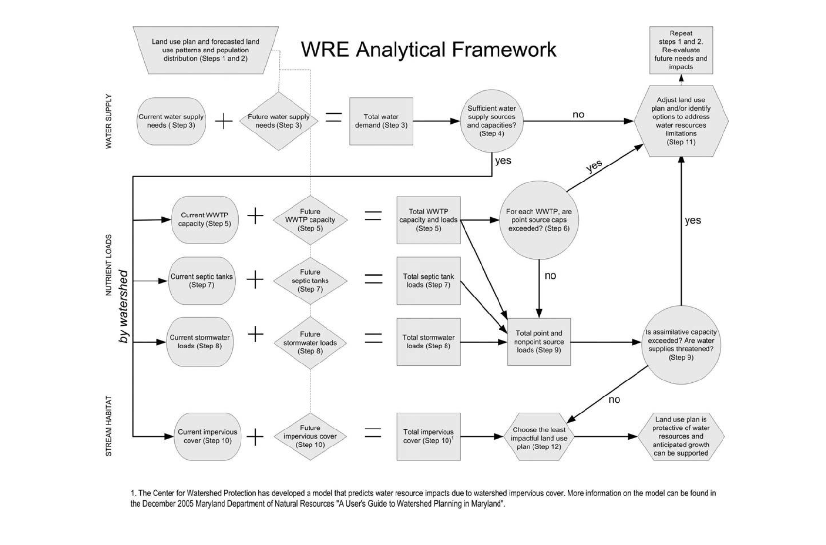
Figure 2. Water resources element analytical framework
Step 1. Land Use Plan
Consider population projections for the planning period and choose a land use plan that will result in desired development densities and locations, given all of the goals and recommendations of the comprehensive plan. The population projections should bear a reasonable relationship to countywide projections that are derived from the MDP cooperative forecasting process. Because of the nature of WRE analyses, this land use plan might be a first draft – revisions might be necessary as a local government explores water resource demands and impacts of the plan. Deciding on a land use plan will require significant county and municipal cooperation.
Step 2. Land Use Pattern
After choosing the land use plan and defining the zoning that will be needed to implement the plan, forecast the likely land use patterns that will result (e.g., development densities and locations). MDP’s Growth Model can be used to make this forecast.
Step 3. Water Demand
Assess current water needs from existing development. Then, considering future land use patterns and population distribution, assess future and total water needs. Use MDE’s Water Supply Capacity Management Plan Guidance.
Step 4. Water Supply Capacity
Given the distribution and amount of water demand, determine whether water supply will be sufficient to support that demand. If water supply will be a limiting factor, go to step 11, Adjust Land Use Plan or Identify Options to Address Limitations. Options to address limitations should include realistic means of finding and developing new water supply sources, establishing stronger conservation measures, modifying planned development patterns or levels or making new development contingent on developing new water supplies.
Step 5. Wastewater Treatment Plant (WWTP) Demand
For each watershed, identify current WWTP discharge locations and loads. Then, considering future land use patterns and population distribution, identify future and total WWTP capacity needs. Use MDE’s Wastewater Capacity Management Plan Guidance (WCCMP). Next, given future capacity needs and distribution, identify future and total discharge locations and loads.
Step 6. Wastewater Treatment Plant (WWTP) Limits
Every WWTP that discharges into the Chesapeake Bay and its tributaries has been assigned a nutrient loading cap. These point source caps are defined by Maryland’s Tributary Strategy. In addition, nutrient waste load allocations have been established in Total Maximum Daily Loads (TMDLs) both within the Chesapeake Bay drainage area and elsewhere in the state. The limitation for a particular WWTP is the more stringent of the Tributary Strategy point source cap or a local TMDL. Also according to the Tributary Strategy, all future treatment plants with a surface discharge have zero nutrient allocation and must therefore offset 100% of their nutrient load.1 Given the distribution and amount of WWTP demand, determine whether WWTP limits are an issue. If WWTP limits do apply, go to step 11, Adjust Land Use Plan or Identify Options to Address Limitations. For cases in which the cap or TMDL might be exceeded:
a. Identify options for ensuring consistency with the cap/TMDL. These might include enhanced levels of wastewater treatment, point-to-point trades, offsetting with nonpoint source reductions, land application (e.g., spray irrigation) and repair of excessive inflow and infiltration. For plants that may exceed their nutrient cap, safeguards should be put in place in the local decision-making process to prevent decisions that would allow development to occur in conflict with the cap. These same considerations should be addressed for new treatment plants being considered to serve new development.
b. Identify the necessary studies that would be needed to support these alternatives
Step 7. Septic Systems
For each watershed, identify septic tank locations and loads. Then, considering future land use patterns and population distribution, identify future septic tank locations and loads.
Step 8. Stormwater Runoff
For each watershed, given current land use patterns and best management practices (BMP) locations and types, calculate current stormwater loads. Then, considering future land use patterns and BMP locations and types, calculate future and total stormwater loads. Technical assistance from MDE and MDP will be provided upon written request for this nonpoint source analysis.
Step 9. Overall Development Impacts
For each watershed, calculate the total nutrient load, which includes nutrient loads from current and future WWTP discharge, septic tanks and stormwater runoff. Compare the total nutrient load for each watershed with the assimilative capacity of the water body. The water body assimilative capacity is the total pollutant loading a water body can receive without violating water quality standards. For impaired water bodies, MDE calculates this through the TMDL process and establishes a total TMDL (point source and nonpoint source TMDL allocations combined) for the water body. In addition, assess whether the total nutrient load will threaten water supplies. If overall development impacts will be a limiting factor, go to step 11, Adjust Land Use Plan or Identify Options to Address Limitations. For cases where septic tank pollution is conributing to exceed the water body assimilative capacity:
Develop plans to account for offsetting the nitrogen loads from new septic systems. Consider the pros and cons of requiring denitrifying technology on new development. Either identify specific remediation options or the studies needed to identify nonpoint source offset options, such as reforestation, riparian buffers and emerging innovative technologies.
Step 10. Impervious Cover
For each watershed, given current land use patterns, calculate impervious cover. Then, considering future land use patterns, calculate future and total impervious cover.
Step 11. Adjust Land Use Plan or Identify Options to Address Limitations
If limits are reached at any of the above steps, especially steps 4, 6 and 9, the land use plan from Step 1 may need to be adjusted, or options should be identified that will help mitigate the limitations.
Step 12. Choose Land Use Plan with the Least Impact
1 Note that the regulatory guidance for offsets and trades has not been completed at the time of this guidance document.
