A. Drinking Water -Water Balance
Applicability
The water balance approach is not applicable for those watersheds where water will be supplied solely by surface water sources and, therefore, should not be developed for watersheds that fall into this category. The water balance calculations presented herein are intended for evaluating ground water supplies in fractured rock, carbonate rock and consolidated sedimentary rock, not coastal plain aquifers.
Disclaimer
This approach calculates the upper limit on what is available. The quantity indicated by the water balance may not be extractable. Further, the water balance does not consider seasonal effects of ground water withdrawals on base flow. Also, the procedures described herein are intended for planning purposes. A watershed-based calculation does not replace site-specific analysis for a water appropriation permit and, in some areas of the state, is an oversimplification of the procedures that would be necessary for permit analysis. For example, a permit analysis restricts the amount available to the land owned or served by a permitee within the watershed in which the withdrawal occurs. The boundaries of the relevant watershed are determined in the permit process. A permit analysis also deducts the acreage that is under impervious cover.
Recharge
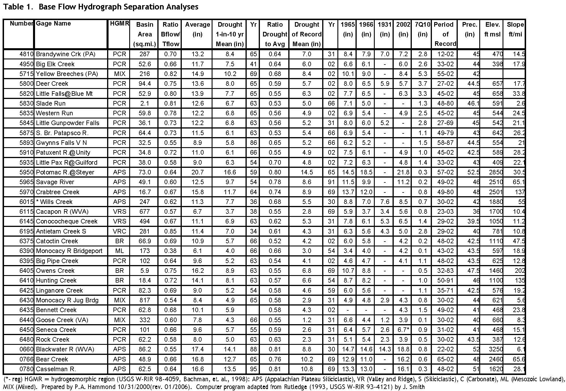
Effective recharge1 or base flow has been computed by the Water Supply Program (WSP) at a number of stream gages using a base flow separation analysis. The general procedure for computing the recharge that can be allocated for water appropriation in a watershed is as follows: select an appropriate stream gage from Table 1 on page 64; determine the 1-in-10 year drought effective recharge in inches and the 7-day-10-year low flow (7Q10) in inches from the table; then subtract the 7Q10 from the drought year effective recharge to yield the recharge that is available for water appropriation.
Selection of Stream Gage
The first step is to determine the hydrogeomorphic rock type(s) in the watershed using the
USGS OFR 00-424, Hydrogeomorphic Regions of the Chesapeake Bay Watershed2 GIS coverage. If there is more than one rock type in a watershed, the area for each rock type within the watershed must be determined and the recharge for each rock type must be computed separately. For the small portion of Cecil County not covered by USGS OFR 00-424, the rock type is PCR (Piedmont Crystalline). For that portion of Garrett County not covered, the rock type should be assumed to be APS (Appalachian Plateau Siliciclastic).
The procedure for determining the appropriate stream gage to represent each rock type from Table 1 varies by county.
For Cecil, Harford, Baltimore, Howard, and Montgomery counties and the city of Baltimore
If the rock type is PCR (Piedmont Crystalline) you will choose from stream gages with a HGMR (column 3 of Table 1) of PCR. Choose a gage within the same watershed, if possible. Otherwise choose the closest gage with an HGMR of PCR.
If the rock type is PCA (Piedmont Carbonate), use gage 5715 (Yellow Breeches, PA).
For Carroll County or Frederick County
For the Catoctin Basin, use stream gage 6375 (Catoctin Cr)
If rock type is PCR (Piedmont Crystalline):
a. If east of Parrs Ridge, choose from 5820, 5830, 5835, or 5875. If West of Parrs Ridge, choose from 6395, 6425, or 6435.
b. Choose stream gage in the same basin, if possible.
c. If step (b.) did not resolve the choice of gage, choose the closest gage.
If Rock Type is Carbonate (PCA or VRC):
a. In Carroll County, use 5715.
b. In Frederick County, use 6195.
If Rock Type is ML (Mesozoic Lowlands), use stream gage 6390 (Monocacy R Bridgeport).
If Rock Type is BR (Blue Ridge), use closer of 6375, 6405 or 64103.
For Washington County
Caution: In addition to the other cautions in this document, accurate estimation of recharge for the area west of Sideling Hill requires the use of procedures beyond the scope of this document. Values computed for this area are for rough planning purposes only. When computing recharge for areas west of Sideling Hill, consult the Water Supply Program for technical assistance.
If Rock Type is BR (Blue Ridge), use closer of 6375, 6405 or 6410.
If Rock Type is VCR (Valley and Ridge Carbonate), use 6195 (Antietam Cr).
If Rock Type is VRS (Valley and Ridge Siliciclastic):
a. East of Sideling Hill, use 6145 (Conococheaque Cr)
b. West of Sideling Hill, use 6115 (Cacapon R WV) but see the caution (above).
For Allegany County:
Caution: In addition to the other cautions in this document, accurate estimation of recharge for the area east of Collier Mountain/Bush Ridge/Martin Mountain requires the use of procedures beyond the scope of this document. Values computed for this area are for rough planning purposes only. When computing recharge for this area, consult the Water Supply Program for technical assistance.
If rock type is VRS (Valley and Ridge Siliciclastic), use 6115 (Cacapon R WV).
If rock type is VCR (Valley and Ridge Carbonate), use 6195 (Antietam Cr).
If rock type is APS (Appalachian Plateau Siliciclastic), Choose from 5965 (Savage River) and 6015 (Wills Creek):
a. Choose stream gage in same (eight digit) basin, if possible
b. If step (a) did not resolve the choice of gage, choose the closest gage.
For Garrett County
Within the Potomac drainage (DNR eight digit basins 02141004, 02141005 or 02141006), Choose from 5965 (Savage River), 5970 (Crabtree Creek), or 5950 (Potomac R. @Steyer)
a. Choose stream gage in same basin, if possible.
b. If step (a) did not resolve the choice of gage, choose the closest gage.
Within the Casselman River Watershed, use 0780 (Casselman R)
For DNR twelve digit watersheds 050202010015, 050202010016, 050202010018, 050202010020 050202010021, and 050202010022—
a. Use 0766 (Bear Creek).
b. Otherwise, use 0660 (Blackwater R WV).
Click to enlarge
Computation of recharge available for use
For each rock type in the twelve-digit basin you are interested in: compute the area in acres; select the 1-in-10 year drought recharge and 7-day 10-year low flow (7Q10) from Table 1; and compute the recharge available as:
[Available Recharge] = [Drought Recharge] - [7Q10])*[Area]*(74.346)
Where:
[Available Recharge] is the recharge available for all existing and proposed appropriations in a watershed in gallons per day;
[Drought Recharge] is the effective recharge during a 1 in 10 year drought in inches per year from column seven of Table 1;
[7Q10] is the 7-day 10-year low flow in inches per year;
[Area] is the area in acres and
74.346 is a conversion factor changing acre-inches per year to gpd.
Then sum the recharge available for appropriation from all of the rock types within the twelve-digit watershed to obtain the total water appropriation that could be supported in that watershed. Note that this recharge must support all ground water appropriations; existing and proposed, regardless of whether a permit is required for that water use.
- Effective recharge differs from actual recharge in that the latter includes ground water evapotranspiration.
- USGS OFR 00-424, Brakebill, J.W. and Kelley, S.K, U.S. Geological Survey, 2000, water.usgs.gov/lookup/getspatial?HGMR
