Analysis of Rural Resource Lands: Status, Vulnerability, Threat and Land Use Stability
Establishment of Base Geographies for Rural Resource Lands – consist of natural resource lands and other resource conservation lands
- Natural resource lands were defined by the Maryland Department of Natural Resources as areas containing the following ecological resources:
- Green Infrastructure
- Rare Species Habitats
- Aquatic Life Hot Spots
- Forests Important for Water Quality Protection
- Other resource conservation lands were defined by counties through their zoning classifications, specifically lands that each county has designated for resource conservation and/or agricultural preservation in its zoning language.
Input Data
The following datasets were used to conduct the analyses
- Maryland Property View 2006
- MDP's Development Capacity Model
- County Zoning and Sewer Service Data
- Priority Funding Area Boundaries
- MDP's Protected Lands Data
Analysis Parameters
The defined geographies were converted to a 100 acre grid cell network in order to aggregate residential parcel information. Statistics were calculated within each cell and also for adjacent or surrounding cells (for some parameters). Areas inside Priority Funding Areas or otherwise outside the boundaries of combined “natural resource” and “other resource conservation” lands were excluded from the analysis.
Status
This analysis is a measure of fragmentation due to residential subdivision and development; the number of residential parcels (improved or un-improved) per 100 acres. Each cell was assigned a value as stipulated:
- Highly Fragmented – More than 5 Residential Lots per 100 Acres
- Moderately Fragmented – Between 3 and 5 Residential Lots per 100 Acres
- Largely Unfragmented – 2 or Fewer Lots per 100 Acres
Vulnerability
Vulnerability is a measure of susceptibility to future residential subdivision and development. The level of vulnerability for each 100 acre grid cell is calculated using MDP’s Development Capacity Model, which is based on the current zoning and land use management tools governing subdivision and development of land parcels. For each 100 acre grid cell, estimated development capacities of all parcels in the cell and the 8 surrounding grid cells are summed (See diagram on map for further explanation).
Each cell was scored as follows:
- High Vulnerability - More than 45 Residential Lots per 900 Acres
- Moderate Vulnerability - Between 19 and 45 Residential Lots per 900 Acres
- Limited Vulnerability – Fewer than 18 Residential Lots per 900 Acres
Threat
Development threat is estimated by using a measure of recent residential market demand to distribute 2030 new household projections throughout a county’s rural resource lands. Residential parcels subdivided or improved between 1997 and 2006 were counted in each 100 acre grid cell. 2030 household projections were then distributed to grid cells in proportion to their share of subdivision and improvement activity from 1997 to 2006. As with the vulnerability analysis, an 8 cell neighborhood grid around each cell was used to represent development pressure in a more generalized way, i.e. in a 900 acre area centered on each cell.
Cells were scored in the following manner:
- High Threat - Pressure for more than 45 Residential Lots per 900 Acres
- Moderate Threat - Pressure for 18-45 Residential Lots per 900 Acres
- Low Threat – Pressure for fewer than 18 Residential Lots per 900 Acres
Land Use Stability
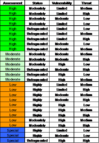
Land Use Stability scores result from unique combinations of the first three analyses (Status, Vulnerability and Threat). The accompanying chart shows how these areas were combined. The relationship between each of the analyses is vital to this scoring method, and they must be reviewed in conjunction with one another. Areas of high assessment appear to have a fairly stabilized land base and can support conservation goals, in light of status, vulnerability and threat. Areas of low assessment appear to have limited prospects to support conservation goals in light of these measures. Moderately assessed lands are somewhere in between, and may be somewhat stabilized or simply not yet subject to much pressure. Prospects for areas of special assessment must depend on what is happening to land around them.
