In Maryland, not every station area with growth potential has a TOD plan to guide development or revitalization. A typical station area encompasses multiple properties and neighborhoods that are either already built, under developed, or vacant. Typically, redevelopment of properties around a station occurs over several years.
In addition to addressing general policies and strategies in a local comprehensive plan to support TOD, jurisdictions should develop a station area TOD plan to define an overall vision for the transit station area with detailed policies and implementation strategies on land use, infrastructure planning and financing, community design and regulatory process provisions. A station area plan is prepared based on assessments of market conditions, the built and natural environments, development capacity, and infrastructure adequacy, as well as analyses of incentives and regulations.
Although TOD has common characteristics, successful implementation recognizes that station area planning must be customized to the unique challenges at each station. In Maryland, existing and future transit stations offer multiple scales and different types of TOD opportunities. Depending upon the community, region, and type of transit system, the TOD station area plan will address development capacity and market potential differently.
Station area planning is often combined with transit corridor and network assessments to maximize the TOD potential. Many cities and regions have used
TOD typology or
TOD Place Types (e.g, categorizing a station area based on recognized characteristics) as a tool for identifying where, when and what planning and implementation activities are needed and evaluating the types of policies and strategies suitable and helpful to realize a corridor- or region-wide TOD vision.
Although TOD plans are not binding, like zoning regulations, they provide a clear direction on how the station area or the corridor should be developed or revitalized to achieve TOD goals. A TOD plan also provides predictability for developers and an opportunity for public involvement during the plan development process, which could help lessen community concerns at a project development stage.
Served by the Washington Metro and multiple MARC lines, with more than 40 transit stations, Montgomery and Prince George’s counties conduct TOD planning and create master plans for their station areas. In the past decade, both counties have increased efforts to complete and update station area plans, providing some of the best examples of TOD station area plans in Maryland.
The White Flint Sector Plan, 2010


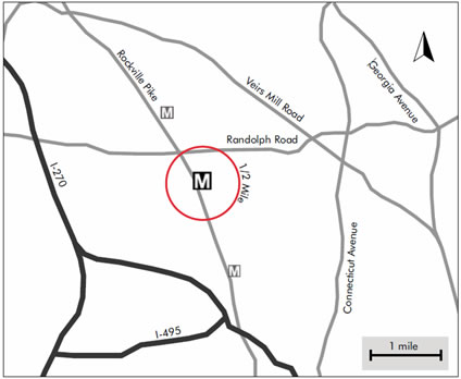
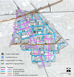
The 2010 White Flint Sector Plan outlines a transit-oriented land use vision for 430 acres within a three-quarter mile radius of the White Flint Metro Station in Montgomery County. The plan establishes a planning framework that will transform a series of auto-oriented commercial strips to a truly walkable, transit friendly, mixed-use and full-day activity urban center. To achieve the vision of TOD, the plan calls for balancing the jobs/housing ratio to encourage more residential development, expand residential and commercial mixed-use to almost the entire planning area, and re-build the transportation network with an emphasis on walkability, reducing auto trips, and increasing the use of transit, walking and bicycling for transportation needs. The planning area is divided into eight mixed-use districts with a range of densities from 1.5 FAR to 4.0 FAR and building heights from 300 feet at the core to 50 feet and lower transitioning away from the core. Each district will be a destination with public space, local retail, recreational areas, and multimodal connections to the rest of the White Flint. In addition, the Plan includes recommendations for zoning, urban design, staging plan, and funding mechanisms to ensure plan implementation.
The Southern Green Line Station Area Plan, 2013
 Metro Green Line Corridor, Prince George’s County
 The
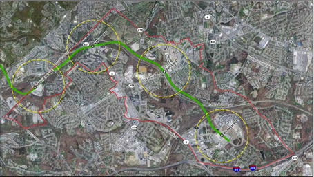
Southern Green Line Station Area Plan provides a good example of how TOD typology is used for different types and intensities of TOD plans for the four station areas along the southern segment of the Washington Metro Green Line in Prince George’s County.
Considering the different conditions, challenges and opportunities for the four station areas, the county developed a unifying corridor plan that includes wider comprehensive planning policies and strategies as well as detailed recommendations on land use and zoning, development concepts and programs, site designs, and multimodal transportation strategies for each station area.
 Southern Green Line Station Area Plan, Prince George's County
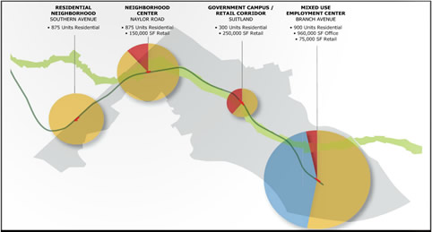
 What is unique about the plan is that the county identified and designates a specific functional role or TOD typology for each station area so each plays a different role in the Green Line while they function collectively in the corridor. The TOD typologies and corridor-wide strategies are developed based on the analysis of the corridor-wide and station areas’ factors, e.g., land use, transportation access, development potential, area topography, real estate market conditions. For instance, TOD at Branch Ave is defined as a regional mixed-use employment center while the one at Naylor Road is a retail and residential mixed-use neighborhood center.