Land Use Map Update Project
The Maryland Department of Planning is starting a update to its statewide Land Use GIS product. The Land Use Map is envisioned to show generalized locations of developed land, including varying densities of residential land as well as commercial, industrial, institutional, other developed, and undeveloped resource land. Previous versions of the map have been used by the Maryland Department of Planning and other public and private stakeholders to support various planning efforts.
Learn more at the Statewide Land Use Map Update page.
Introduction
The Land Use & Cover map and data is used to show development trends on the landscape in Maryland. The Maryland Department of Planning (MDP) created the first Land Use/Land Cover map in 1973 and updated it in 2002. This is the first revision since 2002 and includes several enhancements for a more accurate analysis of land-use change. Data for the analysis came from a combination of aerial photography and parcel data from MdProperty View. The updated dataset is reviewed by local jurisdictions and comments are incorporated into the final product.
The map classifies the land area of Maryland into 13 distinct types of land use (i.e. low to high density residential, commercial, industrial) or land cover (i.e. agriculture, forest) and is used by MDP other state agencies and public and private stakeholders to follow trends in land development and consumption of resource land over time. Mapping these changes is a key informational tool in addressing future smart growth issues in the State.
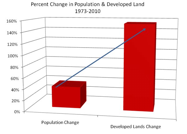
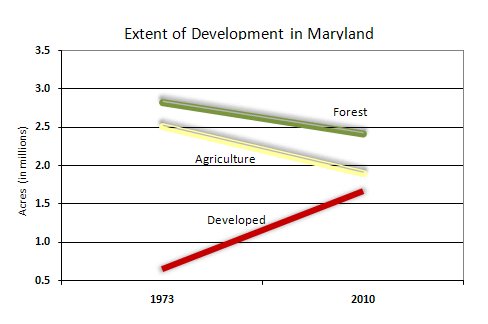
This latest version shows that 1.6 million acres or 27 percent of the State's total land area is developed -- more than double the total surveyed in 1973. During this same period the population increased by only 39 percent.
The information in the summary documents below is based on a 2002 Land Use/Land Cover map, which was modified slightly to align more clearly with the new 2010 version. This reconciliation process is described in more detail below.
Summary - MDP 2010 Land Use
Get downloadable Land Use/Land Cover data for 1973, 2002, and 2010
Statistics and Maps by Jurisdiction
State of Maryland
Allegany, Anne Arundel, Baltimore City, Baltimore, Calvert, Caroline, Carroll, Cecil, Charles, Dorchester, Frederick, Garrett, Harford, Howard, Kent, Montgomery, Prince George's, Queen Anne's, St. Mary's, Somerset, Talbot, Washington, Wicomico, Worcester


Land Use/ Land Cover Map
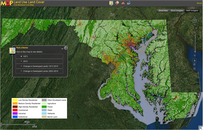
MDP is a comprehensive source for maps of current Land Use/Land Cover for every jurisdiction in Maryland. The Land Use/Land Cover Interactive Map allows you to view, zoom and pan our digital map "layers." These include:
- 1973 Land Use/Land Cover
- 2010 Land Use/Land Cover
- 1973 - 2010 Change
- 2002 – 2010 Change (based on modified 2002 release)*
* Enhancements to the 2010 Land Use/Land Cover release impacted the ability to perform comparative analysis with original 2002 release data. MDP resolved this by creating a modified 2002 Land Use/Land Cover product. To read more about this process, please refer to Mapping Process and Methodology.
Click on the picture of the map below to begin using MDP's Interactive Land Use/Land Cover Map. To familiarize yourself with the 2010 Land Use/Land Cover release, please refer to these materials:

Click to access the interactive map
For more information, please contact: Planning's GIS Section, 410-767-4500.